
Local hiking trails
In this section, you will find contact information of Zakarpattia institutions that provide premises for organising business meetings, conferences and forums.
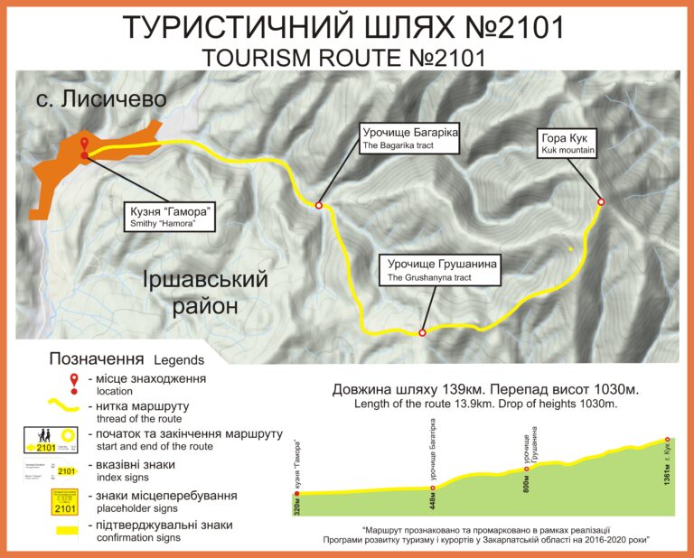
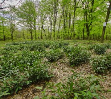
Hamora smithy - Mount Cook
The route starts in the village of Lysychovo, Khust district, from the Hamora Museum and Forge. It connects the historical and technical monument of culture and Transcarpathian Tourist Route. It will help travellers to climb to one of the peaks of the Polonynsky ridge while exploring the cultural heritage and active tourists travelling along the Transcarpathian Tourist Route to visit a unique cultural monument.
The geographical area of the route: The Ukrainian Carpathians, the Polonyna ridge, the Borzhava massif and the Kuk valley.
The length of the route is 13 km, the altitude difference is 1030 m, and the journey takes 2 hours and 30 minutes.
Brief information about the route. It runs from the valley of a mountain river to the top of the massif, and is interesting for the possibility of observing the change in vertical zonation in the flora and fauna: from the forest belt to mountain meadows (subalpine). There is a possibility to set up rest stops and campsites in the Bagarika ur. and in the vicinity of the Hrusanyna ur.; mobile communication is available, but the signal is weak on the section from the Bagarika ur. to the Hrusanyna ur.
You can visit catering establishments and receive medical care in the village of Lysychovo.
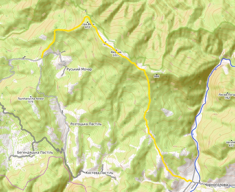
"Russky Mochar - Chornogolova"
The length of the route is 12.5 km, with an altitude difference of 760 m. The average journey time is 4-7 hours. This is a one-day route that connects the villages of Ruskyi Mochar and Chornoholova in Uzhhorod district, crossing the Yavirnyk ridge. The marking was updated in 2016 and is yellow.
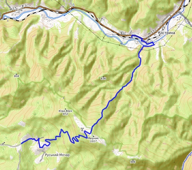
"Russkiy Mochar - Kostrino"
The length of the route is 13 km and the altitude difference is 736 m. The average journey time is 4-7 hours. The route connects the villages of Ruskyi Mochar and Kostryno and crosses the Yavirnyk ridge. The colour of the marking is blue.
"Knyaginya meteorite"
Length: 14 km, 5 km
Type of route: pedestrian
Key points along the wayKnyahynya village - Chorni Mlaky tract - Dubovyi Hai tourist centre (14 km); Stuzhytsia village - Chorni Mlaky tract-s. Stuzhytsia (5 km)
On 9 June 1866, the largest meteorite in Europe fell on the territory of the village of Knyahynya (Uzhhorod district, now the National Nature Park), which was later named Knyahynya.
In general, it is believed that the meteorite broke up into about 1,200 pieces, which fell on the territory of the villages of Nova Stužica, Knyahynya and Strychava (in the then Uzhansky County) and the village of Zboj, Zemplín County (now part of Slovakia). In addition to the largest fragment, which is stored in Vienna and is considered to be the meteorite's core, another rather large part of it, weighing 46 kilograms, is in the Hungarian National Museum. Local historian Petro Sova also wrote that people described almost all of the fragments found as black stones, as if covered with a thin transparent "glaze" with a metallic sheen. Their surface was uneven, and often clusters of small grains of white, yellowish, red, and even blue were visible on the fractures.
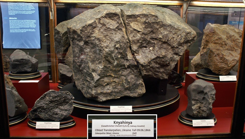
It is impossible to find the wreckage with a metal detector because Knyaginya is a stone meteorite. In addition, most of the fragments fell into forest thickets and ravines, where they are difficult to see. This means that pieces of Knyagynya can still be found by wandering along the tourist path that was opened to mark the 150th anniversary of the arrival of this mysterious meteorite.
Ecological route: Knyahynya village - Chorni Mlaky tract - Dubovyi Hai tourist centre, 14 km long, and Stuzhytsia village - Chorni Mlaky tract - village. Stuzhytsia, with a length of 5 km, marked by the Uzhok National Park. The marking is red.
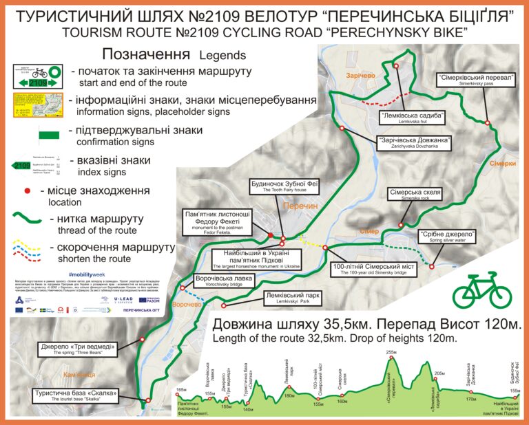
"Perechinskaya bitsiglya"
Length: 35.5 km
Height difference: 125 м
Duration: 3 hours
Type of route: cycling
The circular route starts in Perechyn near the monument to the postman F. Fekete. This is the only monument in Europe to a postman who walked up to 60 km every day for 30 years to deliver mail to people.
We go to the village of Zarichevo, where you can drink pure spring water near the "Silver Spring", to the Lemko Estate. This is a unique museum that reflects the life and everyday traditions of one of the ethnic groups of the population - the Lemkos. The house was built by a local carpenter back in 1902. It offers a beautiful view of the Uzhanska Valley.
We are driving through the Zarichivskyi Pass, which connects two villages of the Perechyn UTC - Zarichyovo and Simerky. We pass by the Simerka rock, where locals used to quarry stone. And a little further, in the forest, there are graves of soldiers who died in the battles that took place in these places during the Second World War.
After the village of Simer, our next destination, we cross the Simer Bridge, which was built around 1900 by Austrian engineers using the Eiffel Tower technology. Next, we pass the village of Vorochevo and stop at the Skalka student camp. We cross the bridge and turn towards Perechyn.
We pass by the Three Bears spring, where you can refresh yourself with delicious water, and end our journey at the monument to the legendary postman F. Feketa.
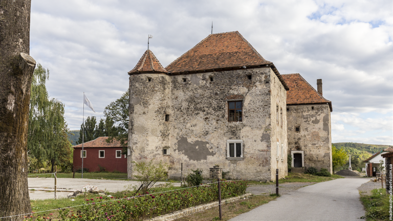
A sports and educational route. "Castle St.-Miklos"
Length: 5.78 km
Пeregulation of heights: 17,1 - 147,1 м
Average journey time: pedestrian - 1 hour. 30 min. and 15 min. by bicycle.
Key points along the wayThe route begins at the monument to the defenders of Mukachevo from Austrian troops in 1849 and passes through the territory of Kolchyn and Chynadiyevo village councils to the castle "Saint Miklos" along the regional road O-071001 Svaliava-Mukachevo (km 12+474-km 20+556).
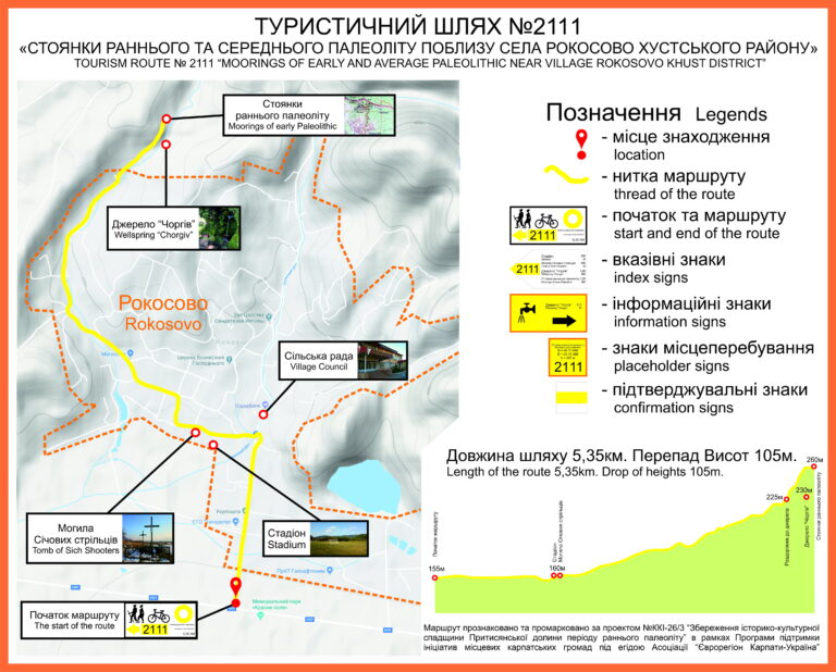
"The parking lots of the early and Middle Paleolithic sites in the vicinity Rokosovo village, Khust district District"
The length of the route: 5.35 km
Пeregulation of heights: 105 м. At the end of the total distance, the route reaches its maximum height of 260 m above sea level.
Average travel time: 1-2 hours
Type of route: pedestrian
Key points along the wayRokosovo village - Zabiy tract - primitive man sites - Mt. Tolstaya (998 m) - Boykove tract
"Ploteni's Way"
The route connects two settlements: Velyki Lazy village and Yarok village of the Baranynska AH, namely the Ploteni Palace and Dil Yarotskyi mountain.
The length of the route: 16.2 km.
Пeregulation of heights: 666 м.
Average travel time: 3 hours (Almost halfway along the route, there is a foresters' house that can accommodate up to ten travellers).
Most of the route passes through beech and oak forests. In addition, the route passes along an 18th-century stone road. Along the route, you can visit the Ploteni Palace; a park of culture and recreation; a forestry house from the Czechoslovakian period; a nursery of the Uzhhorod Forestry; 18th-century iron ore exploration adits; two water sources; a hunting lodge; the highest football field in Uzhhorod district; and Mount Dil Yarotskyi. Mobile communication is available throughout the route.
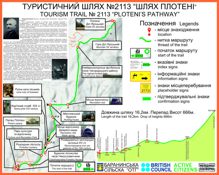
The route was marked at the end of 2019. It was implemented as part of the project "Hiking trails unite the community", which won the pitching of youth projects within the framework of Active Citizens Ukraine with the assistance of the Baranyntsi village council and the NGO "Youth Platform". Tourist signs at the beginning and end of the route, information signs to inform about the tourist's location, and tourist directional signs at key points along the route were installed. Along the route, there are painted confirmation tourist signs that are easy to follow while walking the route.

No comment